The sea level at a particular location is the effect of many factors that vary in strength over time. Along the coast of Sweden the sea level is mainly affected by air pressure and winds in the North Sea and Baltic Sea, together with periodic oscillations in the seawater basins.
This essentially means that when strong winds force the water along the coast the water level will sink. This movement in the water continues to the coast on the opposite side of the basin where the water level will rise. It can oscillate back and forth a number of times.
The water level is registered by SMHI at around 20 measurement stations along the coast of Sweden.
Climate change leads to increased water level
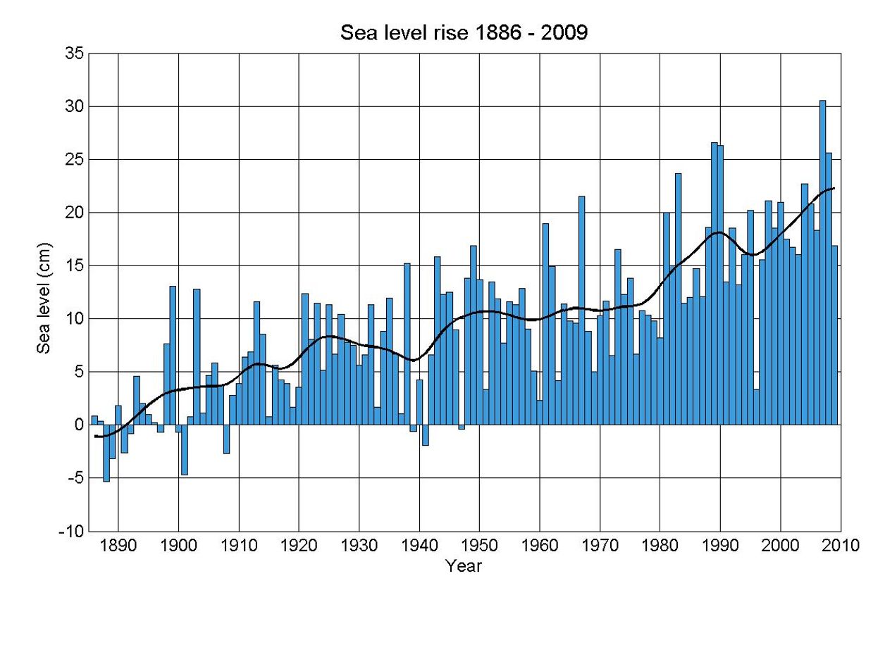
The time series for sea level are long and therefore interesting from a climate perspective. An increase in atmospheric temperature can cause glaciers and land ice to melt faster than they build up, as well as causing the sea temperature to increase and thus the seawater to expand. This leads to a global increase in sea level.
The UN’s Intergovernmental Panel on Climate Change (IPCC) reported in 2007 that the likely increase in sea level from the end of the 1900s to the year 2100 will be 18-59 cm. However new results show that land ice is melting faster that was previously expected, and an increasing number of climate experts are now mentioning a metre as a realistic sea level increase.
People in many parts of the world already experience the effects of sea level rise. In Scandinavia the increase is not so noticeable due to land rise, which is most significant in the North. In Southern Sweden however, the sea level has increased by around 15 cm since the end of the 1800s. During the last 30 years the rate of sea level rise has increased to almost 3 mm per year.
In many places in Sweden where land rise is significant, such as along the coast of Västerbotten, the sea level increase will be hardly noticed, but along the coasts of Southern Sweden the sea level will increase more and more.
Calculate high tide
High tide occurs at different times for different coastal locations. There are no prepared tables for the Swedish West coast to show the tidal variation, but the following instructions can be used to calculate when high tide occurs where you are.
At smhi.se you can check the sea level values at Ringhals for the last 24 hours. Since the most important tidal component is caused by the pull of the moon, and the moon has a period of 12 h 25 min, you can calculate the next high tide by adding 12 h 25 min to the time of the last sea level peak.
You will need to check that no other sea level factors cancel out the tide, but this period is always visible. If you want to know further times for high tide then keep adding 12 h 25 min.
This method works for the location Ringhals. For other locations between Göteborg and Ringhals you can proportionately calculate the time of high tide by calculating the tide difference between Göteborg and Ringhals and their geographical distance and using that to extrapolate the time of high tide for a certain distance from Göteborg for example.
Make your own sea level gauge
It is easy to make your own sea level gauge:

- Find a plank at least 2 m long.
- Mark every 10 cm with paint or notches.
- Fasten it to a jetty, far enough into the water so that it shows the same sea level as the current value from the closest SMHI station, from smhi.se. If your jetty lies between 2 SMHI stations then calculate the distance between the two stations and the distance between one of the stations and your jetty, and use that to proportionally calculate the sea level at your location.
- Now you can see what the sea level is in your area whenever you want. Compare with the measurements at smhi.se from time to time.