
Shipping emissions
The shipping industry is one of the greatest sources of emissions of air pollution and greenhouse gases, and studying its effect on the environment, health and climate is therefore vital. The Shipair shipping model can be used to calculate emissions and concentrations for anything between single harbors and entire oceans.

We can help you if you want to:
- Perform environmental impact studies for single ports or larger regions.
- Compare emission scenarios for your ships, ports or regions.
- Refine and/or verify the methodology used for reporting fuel usage or emissions from navigation under international conventions.
- Improve indicators for regional or national environmental objectives.
- Improve input to emission inventories and dispersion models.
The Shipair model
We use the Shipair shipping model, developed by SMHI to improve national fuel usage statistics and emission inventories. The calculations are based on the GPS-position of every ship, which is collected automatically via AIS (Automatic Identification System). For the Baltic Sea, this data is collected by HELCOM via the Swedish Maritime Administration.
For every ship, Shipair combines the collected positions with detailed data of e.g. gross tonnage, ship class, engine type, strength, age and rpm to calculate the fuel consumption and emissions at every given moment. These calculations are done for both main and auxiliary engines as well as for installed boilers, when cruising at sea as well as in port.
 Zoom image
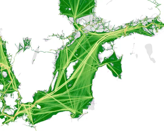
NOx emissions from shipping in the southern Baltic Sea in 2018.
The position of each ship is stored in the Shipair database with a time resolution of five minutes and a spatial resolution of tens of meters or better. We can therefore accurately study the effects even of single ships.
Thanks to the detailed information available for each ship, it is also possible to e. g. calculate emissions only from passenger ships or fishing ships. Based on the ship movement, we can also accurately classify routes into domestic and international traffic.
Combine with dispersion models
We can also combine the calculated emissions with one of the dispersion models available at SMHI. This allows for determining the contribution from the shipping industry to the total concentrations of air pollution in your city or region.