
Forecasts of oil spills
To speed up the clean-up operations after an oil discharge at sea or in larger lakes it is important to know where the oil is drifting and where and when it will reach the coast. With Seatrack Web government agencies can easily make forecasts with hourly resolution, and also track the discharge source.


Seatrack Web is an internet based tool which is used to animate how currents, winds and ice conditions change hour by hour, and how pollutants such as e.g. oil evaporates and drifts. In this way, clean-up operations can be planned and facilitated both out at sea and along the stretch of coasts which are at risk.
Intentional or other discharges can be tracked back in time to their sources with Seatrack Web.
One tool with many opportunities
- Early warnings and drift forecasts
- Tracking of the source of a discharge backwards in time
- Calculate the drift of all kinds of substances such as chemicals, objects and poisonous algae.
- User-friendly interface with the latest forecasts
- Support for Environmental Impact Assessments and risk analyses
Fast and easy to use
Seatrack Web is flexible and you can adjust how the forecast is carried out yourself. The only thing you need to do is to provide the basic information, such as place and type of pollutant. Seatrack Web then simulates the drift and spreading based on weather and circulation forecasts, up to five days ahead. It is also possible to make scenarios with optional winds and currents.
The system is fast and based on the best forecast models for winds and currents and can be reached all day round on the web. The tool is also very easy to use, as it is developed in dialogue with the users and continuously improved.
Graphic presentation
The results from Seatrack Web can be presented as:
- Animated maps in GIS format showing the movement and concentration of the pollutant
- Time series
- Tables containing wind directions/speeds, currents and how the pollutant is changing
The maps also display optional geographic information, for example, sensitive areas. This is useful when calculating risks and when planning clean-up operations.
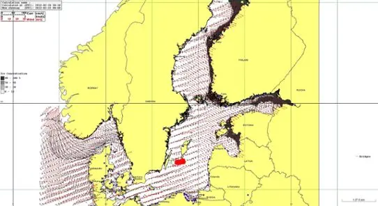 Zoom image
The results in Seatrack Web are presented graphically. The image shows the extent of ice, an oil discharge and a calculation of a fictive oil discharge.
Cooperation around the Baltic Sea
Seatrack Web is used throughout the entire Baltic Sea area, including the eastern part of the North Sea. This means that Seatrack Web is a valuable tool when forecasting pollutants.
The system is developed by SMHI in cooperation with DCOO in Denmark and BSH in Germany. The project is financed by the Swedish Coastguard and SMHI.
Seatrack Web is an important tool which is used by international organisations and authorities. Using Seatrack Web forecasts, reduces the environmental, economic and social impacts.