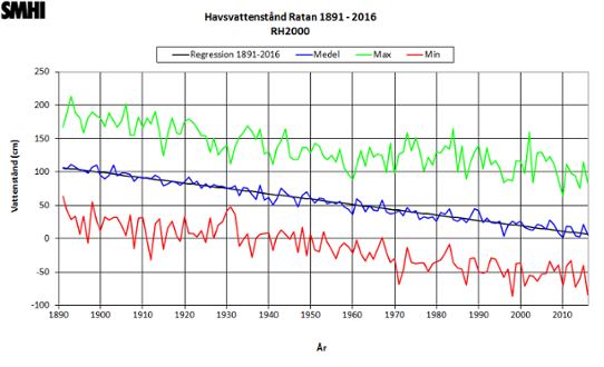
At least 30 years of measurements are used to produce the regression line, which can then be used to estimate sea level both forwards and backwards in time.
Since the mean annual sea level can be calculated, it is used as that year’s datum value from the first day of the year.

Deciding the depth on a navigational chart
The value of the mean annual sea level is used in practice as a reference level for actual depths represented in Swedish navigational charts. These always refer to the mean annual sea level for a particular year calculated in this way, and this is specified on the chart.
If you know the amount of land rise for a year, you can calculate the depth on a chart for that year. The navigational charts sometimes indicate the actual sea level value for stations along the coast in relation to the annual mean sea level.
Other countries use other reference levels. For example, the United Kingdom use the predicted level of the lowest astronomical tide, as it is very rare that the actual sea level is lower than this.