Ice cover is to be expected during a year with normal temperature conditions, if nothing exceptional happens.
However it is not only the average temperature that affects the ice: changes in wind and temperature can make ice more or less severe even if temperatures are normal.
There can also be variations within and between different sea areas, so that ice cover could be considered mild in the Bay of Bothnia but harsh in the Skagerrak. Ice cover for each winter is classified based on the normal conditions for that particular stretch of water.
Effect of the wind
As well as air temperature, wind also affects the sea ice extent. The wind may disperse or pack the ice at sea and creates special conditions that are very significant to marine traffic, such as ice ridges and packed ice along the coast and harbour entrances.
Constant north-easterly or easterly winds, which generally bring low temperatures in winter time, drive existing (and developing) sea ice in towards the Swedish east coast where ridges form that can be hard to break through.
During these conditions the ice situation in the Bothnian Sea is more severe along the Swedish coast than the Finnish coast. Long, wide leads can appear on the Finnish side. However if the wind is westerly or south westerly the ice situation eases along the Swedish coast but becomes more compact further east.
South-westerly winds cause any ice on the west coast to form packed slush in the harbour entrances. This is especially common during the ice breakup period. In the Skagerrak the ice from the Kattegat is also driven north with the currents leading to more difficult ice conditions there.
Normal and extreme conditions
A normal ice winter needs continuous periods of high pressure weather during November and December in the Gulf of Bothnia – giving gentle winds and temperatures under –10 °C.
The ice edge advances southwards during the new year, and the maximum ice cover is often reached some time between the beginning and middle of March. By this stage, the ice covers the whole of the Bothnian Bay, most of the Bothnian Sea, the Bay of Finland and the Åland Sea, as well as the northern Baltic. Thin ice can occur along the coast as far south as the Kalmar Sound.
Over the last few years there have been a couple of very mild winters with a late start to the ice cover. However the winter of 1986/87 was a particularly harsh and icy winter.
Mapping the sea ice
The sea ice extent is of great important to marine traffic, and ice breakers are often required, in particular in the harbours of the northern part Sweden. Ice conditions are therefore mapped every day during the winter period, which is usually from the end of November until the end of May.
The ice meteorologist is helped by detailed reports about the type and thickness of the ice, both from observers along the coast such as harbour pilots and special ice reporters, as well as from the ice breakers that work around the clock clearing the ice-covered areas. Air observations by helicopter also form part of the icebreaking activities.
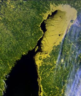
Satellite pictures, mainly from the American weather satellites (NOAA-15, NOAA-16 and NOAA-17) complement the ice reports and provide information with a resolution 1x1 km, showing the large scale conditions as long as there are clear skies over the sea.
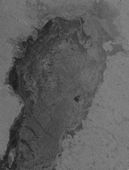
More detailed ice information, down to a resolution of 20x20 m, can be obtained from a satellite-based instrument called Synthetic Aperture Radar (SAR). Both the Canadian RADARSAT and the European ENVISAT are equipped with SAR sensors.
A good description of the current ice situation is also needed as input to the weather forecasting models, since the ice extent significantly affects the weather, in particular in coastal areas, affecting temperature, cloud cover and precipitation.
The daily ice mapping result is also added to a database that is used to generate information such as climate statistics for the Baltic region.

