Background
The Nakanbé-Bomboré sub-river basin, in which the Bomboré River is situated, has experienced an intense withdrawal of surface water to intensify agricultural production for several decades. Agricultural practices following the development of irrigated land have led to a change in the balance of agro-hydro systems linked to the phenomena of erosion and eutrophication. In recent decades, there has been an increase in the number of producers using motor pumps for crop irrigation purposes. Several dozen producers are located there, and carry out market gardening activities during the dry season. These agricultural practices are thus contributing to the degradation of the land, such as silting up the river, reducing soil fertility and water pollution. This is also due to poor agricultural practices linked to the abusive use of inputs (fertilisers and
pesticides) by some farmers in market gardening practices.
Description
The data was collected from a survey of farmers. The pedological profiles were described and collected for laboratory analysis. Emitted CO2 was estimated using the EX-ACT tool, and the RUSLE model was used to estimate the rate of erosion.
According to the results, 46 motor pumps are used by 26 producers to irrigate about 18 hectares of land, with ratios of 1.7 motor pumps and 44 PVC pumps per farmer. They make excessive use of mineral fertilisers, with doses of 168.5 kg of NPK and 62.5 kg of urea per hectare respectively.
Pesticide application doses are around 5 litres per hectare. Agricultural activities emit 222,437 kg of CO2 equivalents, of which 14.5% relates to the use of inputs (fertilisers and pesticides) and 84.5% to motor pumps. The
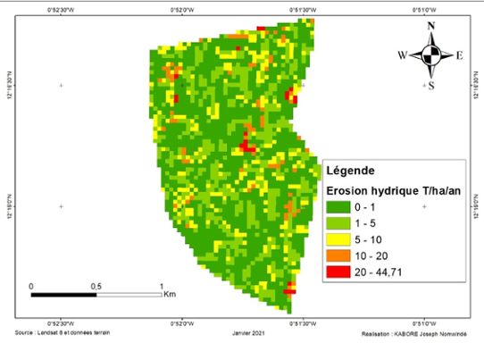
average rate of land loss in the area is 2.30 tonnes/hectare per year (see figure below). There is currently a proliferation of invasive aquatic plants in the Bomboré River, such as Typha domingensis Pers., Eichhornia crassipes (Mart.) Solms or water hyacinth, Cyperus articulatus L., Mimosa
pigra Linn. and Azolla africa Desv.
Impact
The study of market gardening practices along the Bomboré River in the Nakanbé-Dem sub-river basin is part of a reflection on the analysis of the impact of agricultural activities on land degradation. In view of the current land degradation conditions along the Bomboré River linked to agricultural activities, recommendations can be made to improve the restoration and sustainable management of soils, namely training and raising awareness among producers, encouraging integrated water resources management (IWRM), and integrating sustainable land management into municipal and regional development plans. This study thus represents a call for more surveillance/monitoring actions to safeguard in a sustainable manner the soil and water resources of this river, which contribute towards the food security of a population of 73,214 inhabitants in the municipality.
Lessons learned
In terms of perspective, other aspects warrant deeper investigation in order to safeguard ecosystems against the effects of climate change. This will involve an economic study of agricultural production to consider the financial participation of farmers in water management, studying soil and river water pollution, and finally studying the vulnerability of farmers and their capacity for resilience.