
Nowcasting and remote sensing
The focus of this research and development area is to get the most out of the current and soon operationally available new satellite and radar data for the improvement of Nowcasting and Early Warning at SMHI.
Focus of the research area:
- Increase the use of satellite and weather radar data at SMHI to improve both current situational awareness and short-term weather forecasts.
- Continue to develop algorithms for cloud and precipitation analysis.
- Develop and implement methods for short-term forecasts of precipitation in particular, for example through machine learning.
- In particular, make the ever-increasing amount of satellite data ("raw" data and products) more operationally available and stimulate its use in analysis and short-term forecasting.

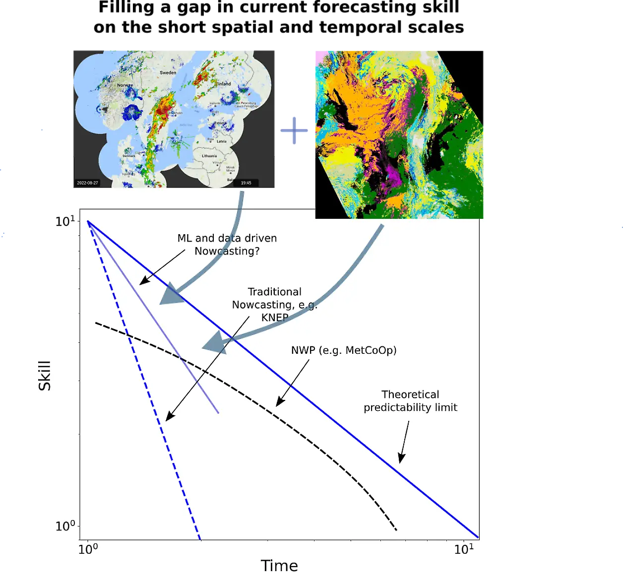
Increasing importance for forecasting
Short-term forecasts of high quality and accuracy at a high spatial scale are particularly in demand by society. Better and more detailed short-term forecasts of, for example, precipitation (location, intensity, phase) and low clouds are examples that can bring major socio-economic benefits to Sweden. Numerical Weather Prediction (NWP) models can currently only make use of a fraction of all remote sensing data. The data assimilation process includes a thinning out of the otherwise high-resolution information needed for detailed descriptions of cloud and precipitation processes at short time scales. Therefore, there is a need and scope for the development of statistical methods (AI/ML) to complement the current NWP. In parallel, it is still essential to support the regional model development within the MetCoOp collaboration so that the high resolution can be better exploited and data from new satellites and products can be used in a more optimal way.
The amount and information content of data from Earth Observation (EO) satellites is growing steadily, as is their importance, especially in numerical weather prediction. But it is not only in weather forecasting that EO satellite data are becoming increasingly important and relevant. Thanks to the increasing diversity of observations, it now affects all disciplines (Meteorology - Hydrology - Oceanography - Climate) within SMHI's field of expertise.
 Zoom image
Satellite and radar data have the potential to close the gap in existing forecasting capabilities at short spatial and temporal scales
Strong growth of Earth observations and better weather radar data
In Europe, this rapid growth in information content and diversity is exemplified by the Copernicus programme (EU EO programme) and especially the Sentinel satellites, with currently 8 satellites in space covering a variety of disciplines including operational meteorology, oceanography and hydrology. EUMETSAT will also soon launch the first satellites in a new series of geostationary and polar satellites to replace the current Meteosat and Metop programmes. The first (3rd generation) geostationary EUMETSAT satellites MTG-I1 and MTG-S1 (MTG programme) will be launched in late 2022 and late 2023, and the corresponding new polar (2nd generation) EUMETSAT satellites Metop-A1 and Metop-B1 (EPS-SG programme) will be launched in early and late 2025.
The Swedish weather radar network has undergone a major modernisation in recent years and now offers new possibilities compared to the past. For example, dual-polarization measurements allow better determination of the phase of hydrometeors (snow, rain, sleet). Sweden's network of radar installations is part of the European OPERA network under EUMETNET.
New opportunities with new observation techniques
The launch of these new programmes will mark a multiple leap forward in data sets while new observational techniques provide new opportunities, for example: lightning detection from space, IR soundings from geostationary orbit and the use of sub-mm wavelengths to observe ice clouds. All of these are completely new to Europe.
In addition, the traditional large and expensive flagship programmes (such as EPS-SG and MTG just mentioned) will be complemented by much smaller and cheaper satellites in the near future. One example is the Arctic Weather Satellite (AWS), a Swedish-led development under ESA, with launch in early 2024, and a planned follow-on constellation (EPS-Sterna under EUMETSAT) with up to 20 satellites over more than 10 years that will provide dense coverage (about every 30 minutes) over Sweden.
Developments in nowcasting and remote sensing require international interaction and cooperation, in particular with EUMETSAT, MetCoOp and our related Nordic weather services (Nordmet/Nordsat and Nordrad), as well as coordination within SMHI to raise awareness of new opportunities, make the best use of available resources and help attract new funding.
