Coastal radars can provide detailed information about the direction and speed of water on the sea surface. This information provides important input for work concerning the ocean environment, transports, oil spills and search and rescue actions.
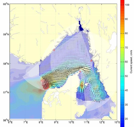
“Data from the system is received once an hour and provides information on the current situation. Data will also be assimilated into models for ocean currents. An investigation will also be made to compare the high frequency radar information with data from satellite pictures”, says Johan Kronsell, project manager and oceanographer at SMHI.
The radar system, which has been rented from the American company CODAR, will be evaluated over a period of 6 months.
Illustration of the coastal radar installation
Contribution from several partners
The coastal radar system is part of a project called SOROS (Scandinavian Ocean Radar Observation System). SOROS is partly financed by EU funds from Interreg IV A Öresund Kattegat Skagerrak as well as with funds from the Swedish Agency for Marine and Water Management.
The project is managed by SMHI in cooperation with Denmark’s meteorologiske institute (DMI) and Norway’s Meteorologisk institutt (MetNo).
Data from the coastal radar system will also be used by the SARACUS project (Using Satellite data and coastal HF radar to map and validate sea surface currents and to detect ships in Skagerrak). Here the radar data will be used to validate data from satellites. SMHI participates in this project together with Chalmers University of Technology and the Swedish Defence Research Agency. External financing for SARACUS is provided by the Swedish National Space Board.
As soon as the installation of the radar system is complete, the data will be available on SMHI’s website, THEME: Marine Environment.
The SOROS project would especially like to thank everyone on Måseskär and Väderöarna for all their help with the installations.