
SMHI issues up-to-date weather forecasts every day of the year. When weather is expected to cause consequences or disruptions in society, a warning is issued. Our meteorologists, hydrologists, and oceanographers use information from advanced modelling systems when making a forecast or issuing a warning.
SMHI works with numerical models. This means that the model is built on mathematical descriptions of the physical processes in, for example, the atmosphere or the sea. Behind the models lies extensive research and development that allows us to incorporate observations and satellite data describing the current state in order to predict conditions for the coming days.
Further developing the models used for different types of forecasts is a team effort. Research and development occurs within large research networks. As supercomputers have become increasingly powerful, it has become possible to use higher model resolution, which provides more detailed forecasts that capture extreme events and rapid developments more clearly.
High-resolution models with many details
Many observations, detailed information and frequent updates are essential -especially during extreme weather situations when developments unfold quickly and societal consequences can be significant.
In a higher-resolution forecast model, more precise descriptions of the physical processes governing the weather are required. As we continue to develop our modelling systems, we create more detailed descriptions of processes in the atmosphere, on and within the ground, in the sea, and in the exchanges between sea, land, and atmosphere. These more detailed models also make it possible to produce new types of forecasts.
Despite greater detail, it can still be difficult to state exactly which area will be hit by, for example, a heavy rainfall event. Therefore, we are developing methods for probabilistic forecasts that help identify the uncertainties present in the predictions.
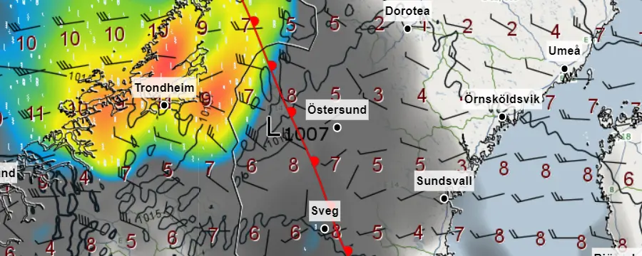 Zoom image
Researchers at SMHI are developing an operational weather forecasting system together with colleagues in several European countries. SMHI meteorologists use the system to issue weather forecasts and warnings.
Forecasts for Water and the Sea
A heavy cloudburst can quickly lead to high flows and flooding that threaten buildings and infrastructure. We are further developing the model that describes what happens when rainwater reaches the ground and spreads downward through the landscape. This enables us to forecast how much water is already present in lakes and watercourses and whether flooding may occur if more rain falls.
Over time, rainwater reaches the sea - carrying nutrients and sediments that affect the marine environment both near the coast and far offshore. We are refining the models that describe the physical processes near the coast and in the open sea: water temperature, currents, and stratification. These models can be used for marine forecasts showing temperature, currents, ice formation, wave height, and warnings for high sea levels.
Current Research for Better Forecasts and Warnings
We conduct research to improve the accuracy and precision of our forecasts across different time scales. We refine descriptions of physical processes and work with new types of observations to better represent the initial conditions at the start of a forecast calculation.
Satellite Data Improve Forecasts
Over the past 30 years, microwave data from satellites have contributed more than any other single source to improving weather forecast reliability. We continuously work to integrate more satellite data into our forecast models through data assimilation. This includes evaluating what different types of satellite data contribute to forecast accuracy.
We also explore new uses for satellite monitoring. Both water flows and ice can be observed with satellites, as well as sea surface temperature and algae blooms. We are investigating how satellite data can be used to improve ice forecasts and increase the consistency between ice forecasts, marine forecasts, and weather forecasts.
New Data Types That Enhance the Picture of Current Conditions
With rapid technological development, many private weather stations now exist. We conduct research on how third-party data can be used to improve forecasts.
We also investigate how drone technology can be used to measure water flows in difficult terrain. Drones are also used to gather data to increase resolution in near-surface weather forecasts, where many small-scale processes influence conditions.
We have successfully developed methods to measure precipitation by examining how much signals between mobile phone masts are weakened by rain. This is useful in areas with well-developed mobile networks but sparse hydrological monitoring stations.
- Discover how precipitation can be observed in the mobile phone network
Read about more topics
Related links
More about research related to forecasts and warning
Our Research Units
All our research is developed through our four research units and the research projects we lead and participate in. Through this research, we advance our models and tools for the benefit of society and SMHI.
Meteorology — Hydrology — Oceanography — Climate at the Rossby Centre
National and International Collaboration
A large part of our research and development is carried out in cooperation with others.
Models based on research and development
Examples of models used for forecasts and warnings:
Research projects that develop
Examples of research projects that develop models, methods, and tools for forecasts and warnings: