
Satellites and drones contribute to new hydrological data – from the Arctic to Africa
During a week in May hydrologists from SMHI exchanged the Swedish landscapes for African ones, for field work by the Ogun river in Nigeria. The reason was an ongoing research project which develops new methods for hydrological observations in inaccessible areas, with the help of drones and satellites.
“In this project we develop methods to observe stream flow in places that are inaccessible with traditional methods. The measurements are contactless, meaning no instruments need to be in contact with the water”, David Gustafsson explains, who leads SMHIs work in the project.

Take off for drone measurements. Here coupled with a radar that measures water depth.
Observing stream flow – for forecasts and warnings
“With drones we can use different sensors to measure a range of parameters, such as water depth and slope, speed and height above sea level of the water surface. Together these parameters can be used to calculate stream flow”, says David
Stream flow refers to the amount of water passing through a river per time unit. Observations of stream flow is the foundation of hydrological forecasts, allowing us to predict how hydrological conditions change and issue warnings for extremes such as floods and drought.
“The drone technology is relatively inexpensive and our hope is that the methods will be useful in many parts of the world, including where access to data is limited or non-existent.”
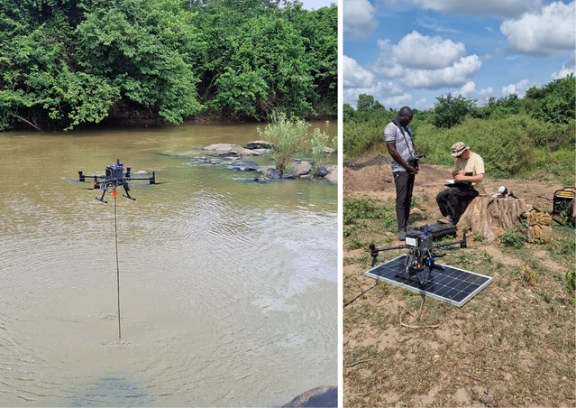
Left: drone measurements with a sonar measuring water depth. Right: the solar panel turned out to have many uses. Both to charge batteries and as a take off pad for the drone.
Challenges and successes in the field
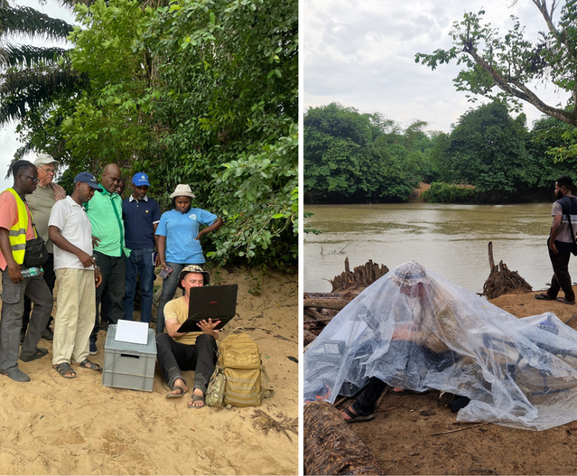
Apart from David and colleague Bode Gbobaniyi from SMHI, experts from the Danish company Drone systems and hydrologists from multiple Nigerian organizations took part in the field work. They represented Nigeria’s hydrological services agency NIHSA, the regional water authority Ogun-Oshun RBDA and Benin drone lab, a local drone operating company. Together they both took on challenges and celebrated successes.
“The field work was challenging in many ways. In particular, it was unexpectedly difficult to reach the river bank in many places due to dense vegetation. Even though we were “only” able to carry out about half of the measurements we had planned, we’re very happy with the results we got”, says David.
.png)
Left: Sune Nielsen from Drone systems is showing how the next measurement will be carried out, to the group from Ogun-Oshun RBDA and David from SMHI. Right: creative protection from the rain.
Satellites and drones – a capable duo
The Ogun river was chosen as the test site in Nigeria together with NIHSA. Two requirements were safe conditions for drone measurements and available satellite data.
“The method we’re developing builds on using water-level observations from satellites, instead of measurements from fixed hydrological stations. The drone measurements in turn work as a complement to increase the accuracy locally”, David explains.
“Satellite based observations of relatively good quality are nowadays available for many rivers worldwide. This leaves a good opportunity to develop and share knowledge about how satellite data can be used, and enriched with drone measurements.”
“Risk zone for floods”
The frequent reader of SMHI’s Swedish news feed may remember our article from this fall when the same project, called UAWOS, were on a northward fieldtrip. They were then making test measurements in Torne river along the boarder between Sweden and Finland.
Swedish news article about drone measurements in Torne river (September 2024)
The week on the Ogun river in Nigeria was the next major field effort.
“Many villages along Ogun are in the risk zone for floods. The same applies for Torne river that we visited in September. In both locations there is a local interest to better monitor and predict situations when water flow is high, to know when they can be affected”, David explains.
The project continues
Now all data from the field week will be processed and later this year the project plans to visit Nigeria again. Then, they will continue working with NIHSA to find ways to incorporate the methods into their daily operations.
“Through tests in both Ogun and Torne river, we hope to pave the way for applications of hydrological satellite and drone-based monitoring also in other areas”, David concludes.
About UAWOS
UAWOS – Unmanned Airborne Water Observing System – is a four-year research project financed through Horizon Europe. The project is run by Denmark’s technical university DTU. Apart from SMHI, partners from multiple other European countries engage in the project, who are experts in different aspects of remote sensing and satellite observations.
Read more about UAWOS on the project website (dtu.dk) External link.