The State of Climate Services Report 2020: Risk Information and Early Warning Systems highlights how these systems play a key role in reducing the effects on lives, property and ecosystems in the event of various weather-related natural disasters. Despite this, 90 percent of the least developed countries and small island nations currently lack such a system. The report reveals a significant gap in the ability to translate these warnings into action within society. The contributing organisations also point out that major investments are required in the future, as the climate changes and the risks of extreme weather increase.
Capacity building in West Africa
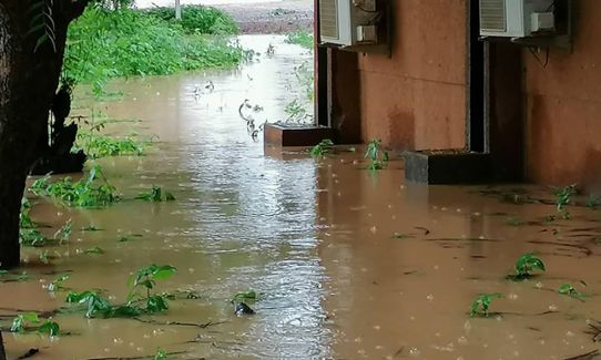
For many years, SMHI has worked together with authorities and regional players in West Africa to develop and build up a system warning of the growing problem of flooding. Participants from 17 West African nations are working with researchers from SMHI to create an operational forecasting and warning service for high flows and flooding in a region extending from Chad in the east to Cape Verde in the west.
For some time now, the countries in this area have been able to use a system to issue warnings of high flows and flooding. The system is based on a hydrological model of the area, of the same type used by SMHI in Sweden. The system also uses local measurements from watercourses in the region. This combination of models and measurements produces high quality flooding forecasts that cover the entire region in real time.
The importance of an overall perspective
“We work with an overall perspective,” explains Jafet Andersson, a research leader within hydrology at SMHI. “As well as creating a robust technological system that generates high quality forecasts, it is also essential to build up local capacity and to create a sense of ownership in the region. It is important for us that the West African authorities can interpret the information and convert it into action within society.”
The system that SMHI has built together with the regional players provides an opportunity to be prepared for and warn of the risk of flooding. However, the researchers have also identified a need for more capabilities within society in order to ensure long-term sustainability, and this is addressed in the new report.
“There are several different types of capability that need to interact with each other,” continues Jafet. “Practical preparations must be effective, such as clearing debris and sand from drainage pipes. There must also be a long-term strategic capability to develop a more resilient society. And not least, there needs to be a society where the population acts on the information and is prepared to leave their homes unattended when there is a risk of flooding, without the risk of their homes being vulnerable to damage or theft in the meantime.”
The forecasting and warning system for high flows and flooding in West Africa is being developed as part of the FANFAR project, which has received funding from the EU’s Horizon 2020 research programme for three years (2018-2020). Useful project findings show how research can create operational production and bring social benefits. The Economic Community of West African States (ECOWAS) has signed an agreement with the regional technical organisation AGRHYMET, a partner in the FANFAR project, to start using the system at its flood observatory. Researchers also see great potential for making further improvements to the warning system, including through the use of additional observation types. One area for development involves using satellite data on water levels to further enhance the quality of forecasts.
According to the United Nations High Commissioner for Refugees, more than 700,000 people have been affected by serious flooding in Africa’s Sahel region this year. By the end of September, 71 people had been reported dead and 90 injured in Niger alone, the country that has been hardest hit this year and where an estimated 350,000 people have been affected by flooding.