
Water is essential for life, yet in many situations knowledge about water resources dynamics is insufficient to meet the needs of society and the environment. Water is both a friend and a foe that constantly changes, so we need to understand, quantify, and try to predict how it changes. Insufficient knowledge can incur large problems for society (e.g. loss of lives and ecosystem services, damaged infrastructure, disrupted transportation, cuts in energy supply, reduced food production, release of untreated sewage to water bodies, and deterioration in public health). However, with accurate and up-to-date water information, society can make more informed decisions and act more appropriately.
In this research field, we explore the potential to better understand and quantify water dynamics by utilizing hydrological models and measurements on large scales (river basin to global scales). Moreover, we apply the knowledge in pilot services across the globe (e.g. in West Africa), in order to maximise societal benefit.
Hydrological dynamics and the water balance
Hydrological systems show large variability across the globe and the response to precipitation is very different; often even neighbouring rivers differ in streamflow and soil moisture. This can be due to e.g. varying physical properties of the landscape, differences in climate, or water management.
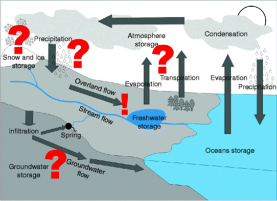
The simple water balance equation Q = P – E – ΔS (where Q = streamflow, P = precipitation, E = Evaporation, and S = Storage) is puzzling hydrologists all over the world. Streamflow can be difficult to monitor due to fluctuations in the river channel, precipitation is often heterogeneous in the catchment area, evaporation from water surfaces or vegetation is difficult to measure, and the storage is normally unknown, especially underground.
To gain understanding of dominant water processes and emergent patterns in a changing world, we combine different types of data (e.g. field measurements, earth observations, radar, meteorological models, etc.) and variables (e.g. topography, precipitation, land use, soil properties, water management etc.) with numerical modelling of hydrological processes. We build and refine numerical hydrological models, primarily using the HYPE code and a set of model development steps including topography-based catchment delineation, process-oriented spatial subdivisions, description of individual hydrological features, calibration, and evaluation. We analyse data from models and observations in order to improve our understanding of hydrological processes and how to model them across the world.
Research and Development questions
Water resources: What are the dominant hydrological processes in different regions around the world? How large is each component in the water balance, and what are the reasons behind similarities and discrepancies? We explore these questions by analysing how fluxes and characteristics differ between catchments in multi-basin models covering many rivers and thus providing large samples of data to analyse (see e.g. Arheimer et al. 2020)
Dynamics: What are the effects of change in the environment and society on key water variables? We explore this question on a range of scales, from short- and medium-range forecasts to long-term retrospective analyses and climate projections.
Accuracy: How accurately can different water variables be quantified across varying spatial and temporal scales, and what are the main factors influencing accuracy?
New data: How can new data contribute to the improvement of process understanding and model accuracy? What is the most robust information content in different data types? How can observations and models best be combined? See for example Musuuza et al., 2020.
Application: How can the knowledge-generation process be optimized in order to facilitate application and create benefits to society? What activities support dialogue between researchers and practitioners? How can working procedures, tools, and pilot services be adapted to support swift and quality-assured applications? One of the approaches we use to facilitate application is to work with open-source tools.
Our core publications in this Scientific focus
Arheimer, B., Pimentel, R., Isberg, K., Crochemore, L., Andersson, J. C. M., Hasan, A., and Pineda, L.(2020): Global catchment modelling using World-Wide HYPE (WWH), open data, and stepwise parameter estimation, Hydrol. Earth Syst. Sci., 24, 535–559, doi.org/10.5194/hess-24-535-2020.
Musuuza JL, Gustafsson D, Pimentel R, Crochemore L, Pechlivanidis I. (2020). Impact of Satellite and In Situ Data Assimilation on Hydrological Predictions. Remote Sensing. 2020; 12(5):811. https://doi.org/10.3390/rs12050811
Andersson J.C.M., Arheimer B., Traoré F., Gustafsson D., and Ali A. (2017). Process refinements improve a hydrological model concept applied to the Niger River basin. Hydrological Processes, 31, 4540–4554, doi.org/10.1002/hyp.11376
Hundecha, Y., Arheimer, B., Donnelly, C., Pechlivanidis, I. 2016. A regional parameter estimation scheme for a pan-European multi-basin model. Journal of Hydrology: Regional Studies, Volume 6, June 2016, Pages 90-111. doi.org/10.1016/j.ejrh.2016.04.002
Donnelly, C, Andersson, J.C.M. and Arheimer, B. (2016). Using flow signatures and catchment similarities to evaluate a multi-basin model (E-HYPE) across Europe. Hydr. Sciences Journal 61(2):255-273, doi.org/10.1080/02626667.2015.1027710
Pechlivanidis, I. G. and Arheimer, B. (2015). Large-scale hydrological modelling by using modified PUB recommendations: the India-HYPE case, Hydrol. Earth Syst. Sci., 19, 4559-4579, doi:10.5194/hess-19-4559-2015.
Arheimer, B., Dahné, J., Donnelly, C., Lindström, G. and Strömqvist, J. (2012). Water and nutrient simulations using the HYPE model for Sweden vs. the Baltic Sea basin – influence of input-data quality and scale. Hydrology research 43(4):315-329. doi.org/10.2166/nh.2012.010
Strömqvist, J., Arheimer, B., Dahné, J., Donnelly, C. and Lindström, G. (2012). Water and nutrient predictions in ungauged basins – Set-up and evaluation of a model at the national scale. Hydrological Sciences Journal 57(2):229-247. doi.org/10.1080/02626667.2011.637497