Since RH 2000 became official in 2005, a transition to the new reference system has been ongoing at Sweden's municipalities, government agencies and other societal stakeholders. For example, the Swedish Maritime Administration is gradually adapting the Swedish nautical charts to RH 2000 (Baltic Sea Chart Datum 2000, BSCD2000), and most municipalities in the country now use RH 2000 to indicate heights in detailed development plans.
A uniform reference system will make things easier for users
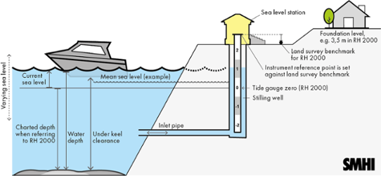
When sea level is specified in relation to the same reference level as depths in nautical charts or heights on land, it becomes easier to calculate the under keel clearance or to find out if a pier, a jetty or the foundation of a house is at risk of being flooded during a coming storm. Exchange of data and analyses involving both land and sea are also facilitated when the same reference system is used.
"We are aware that this transition may cause some confusion initially. Anyone who is accustomed to obtaining sea level information in relation to the mean sea level may need to understand how the systems relate to each other, says Lisa Lind", head of SMHI’s oceanographic forecast and warning service and continues:
"Changing the reference system can be a rather time-consuming process, for example it will take a few years before all nautical charts are adapted to the new reference level. Therefore, it is important to note which reference systems are used in the material you yourself utilize".
The difference between RH 2000 and relative mean sea level
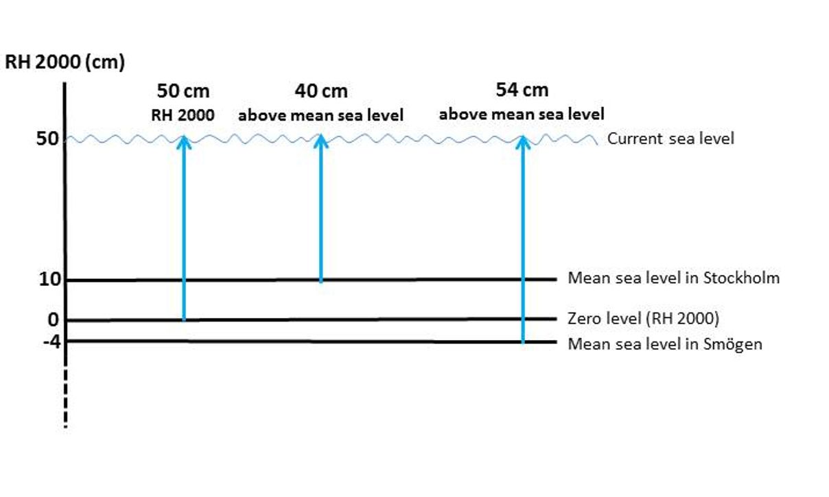
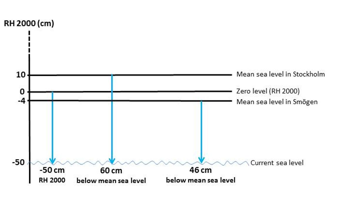
When the current or forecasted sea level is expressed relative to the mean sea level, one gets to know how much the sea level deviates from a theoretical mean value for that particular place. However, this mean value changes over time, and is also different in different places. By expressing the current sea level in RH 2000, one instead gets to know how the sea level relates to a fixed point on land, which constitutes the zero level in the reference system. This zero level does not change over time and is the same at every location. The illustration below explain how it interrelates.

RH 2000 and Baltic Sea Chart Datum
All official Baltic Sea chart manufacturers have agreed to implement the Baltic Sea Chart Datum 2000 (BSCD2000). For Sweden, BSCD2000 coincides with the zero level of the Swedish national height system
RH 2000 and can be regarded as the system’s extension to sea. This means that eventually, nautical chart reference levels will be the same in all countries around the Baltic Sea and relate to the same zero level as RH 2000.
Updated warning levels
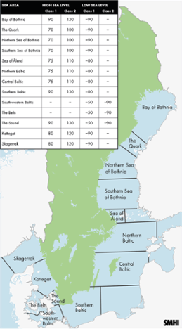
The transition to RH 2000 has entailed a conversion of warning levels for high and low sea level. The new warning levels are a translation of the previous levels to the new reference system, and therefore do not differ significantly from previous levels.

"Because the mean sea level varies at different locations along the Swedish coast, the warning levels in RH 2000 are more diverse between areas. In other words, we have introduced more warning levels than before in order to match them as well as possible to previous levels", Lisa Lind explains.
In addition, warnings for low sea levels are adjusted from class 2 to class 1 in most areas along the Swedish coast. In the Sound, the Belts and South-western Baltic, SMHI will however still issue sea level warnings of both class 1 and class 2 due to the heavily trafficked and sometimes shallow fairways in these areas.
Conversion between RH 2000 and relative mean sea level
"In order to calculate what a specified sea level in RH 2000 corresponds to relative to the mean sea level, in the reference system called RW, you first need to know what the mean sea level for the current year is in
RH 2000 at your location", Lisa Lind explains. This value is then subtracted from the specified sea level in RH 2000.
In the article "Årets medelvattenstånd" (in Swedish) at SMHI’s web site, you can find the calculated mean sea level in RH 2000 for all oceanographic sea level stations.
Those who use large amounts of data and do not want to recalculate the information themselves will be able to download sea level data in the two reference systems RH 2000 and RW (relative to the mean sea level) via SMHI Open Data
Upgraded technique for sea level observations
During the last few years, SMHI and the Swedish Maritime Administration have collaborated on a project to establish a common observation network for sea levels. Within the project, technique for measuring and storing sea level information has been upgraded at all sea level stations. When the project ends in 2019, the network will include about 60 stations along the Swedish coast, all of which will measure the sea level in RH 2000.
"The sea level will be measured every minute at more locations along the coast than before. This will provide increased opportunities to observe rapid sea level changes and contribute to even better forecasts", concludes Lisa Lind.

